
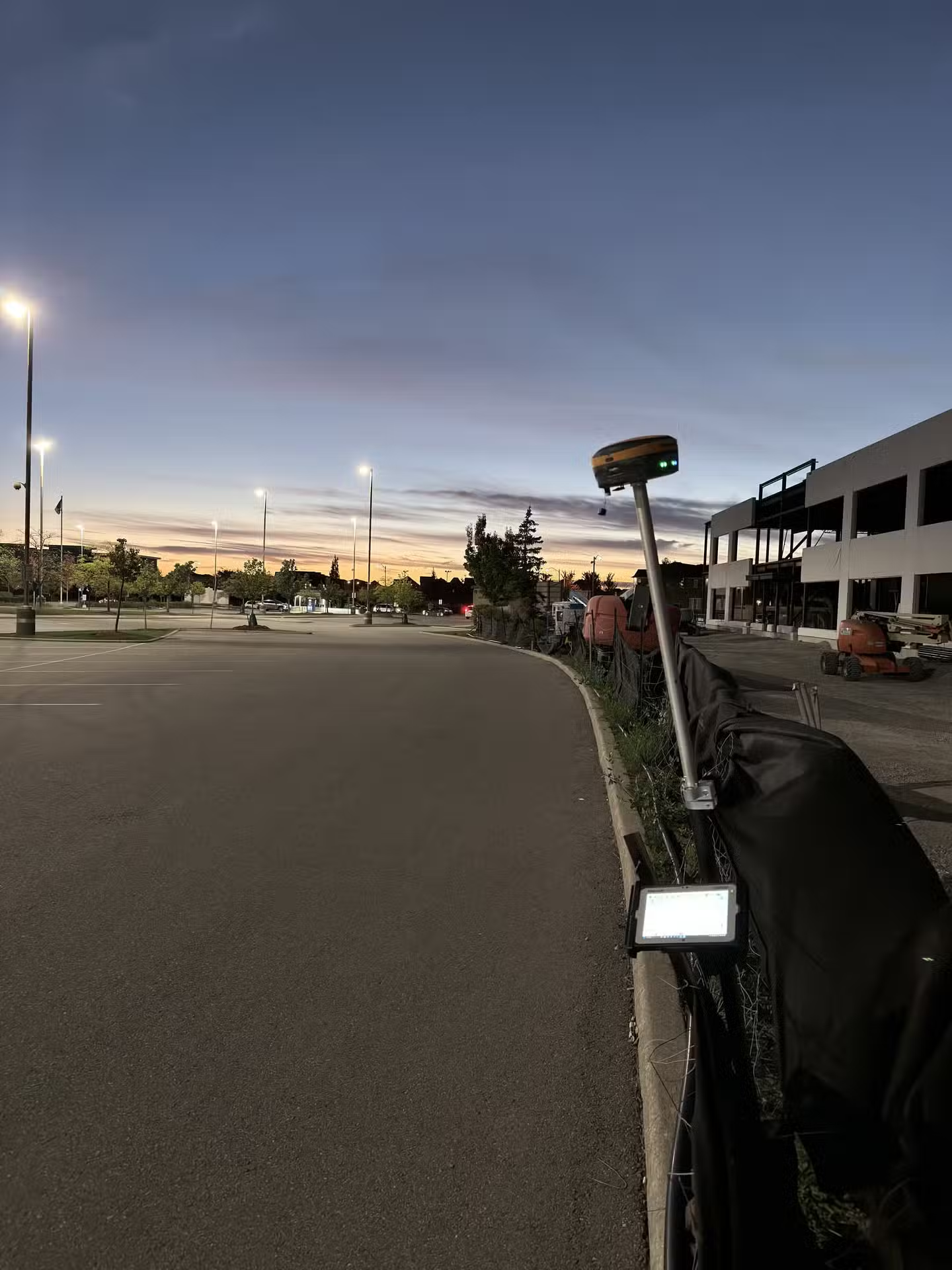
GPS Data Prep and Curb Layout
Introduction
The precision engineering field is continually evolving, with advancements in technology allowing for greater accuracy and efficiency in project execution. One such advancement is the integration of GPS data preparation into engineering processes. This case study delves into a specific project involving precision engineering through the meticulous preparation of GPS data, highlighting its significance, methodologies employed, and the outcomes achieved.
Accurate data is the backbone of any successful engineering project. The reliance on precise measurements and well-structured data ensures that designs are executed correctly, leading to improved safety, reduced costs, and enhanced project timelines. This article outlines the entire process, from file acquisition to the creation of 3D surfaces for machine control, illustrating how each step contributes to the accuracy and reliability of engineering projects.
File Acquisition and Initial Rectification
Obtained CAD File from an Engineering Firm
The first step in the GPS data preparation process involved acquiring a Computer-Aided Design (CAD) file from an established engineering firm. This file contained crucial design aspects that would guide the entire project. The CAD file typically includes detailed drawings and specifications required for the preparation of the site layout.
Upon receipt, the file underwent initial scrutiny to ensure compatibility with the GPS data processing software. This examination included checking the file format, layer management, and the presence of necessary attributes. If any discrepancies or missing elements were detected, the engineering firm was consulted for clarifications or revisions to the CAD file, ensuring the foundation for subsequent processes was robust.
Rectification Process Using Professional Land Surveyor's Control Points
Once the CAD file was confirmed to be in order, the next phase involved rectification. This process entailed using control points provided by a professional land surveyor to ensure the CAD models aligned accurately with real-world coordinates. Control points serve as reference markers that enhance the accuracy of spatial data inputs.
The rectification process included adjusting the CAD file to match the precise geospatial location defined by the control points. By employing a rigorous methodology, any potential errors in the initial data set were corrected, thus laying a strong groundwork for the upcoming data localization and quality assurance phases.
Data Loading and Localization
Loading Data into CAD
With the rectified CAD file ready, the next step involved loading additional site data into the CAD environment. This included importing GPS data captured during preliminary survey sessions. The integration of this data is crucial as it provides real-time positional information that aligns with the designed CAD model.
The loading process also required careful management of layers, ensuring that the GPS data did not interfere with the existing CAD layers. Each layer's functionality must be preserved to maintain clarity and usability. Once the data was successfully loaded, it was essential to verify that all components appeared correctly in the CAD workspace.
Utilizing GPS Base and Rover for Site Localization
The localization of data was achieved through the deployment of GPS base and rover systems, which provide real-time positioning capabilities. The base station, set at a known location, transmits data to the rover, which collects information from various points across the site.
This system allows for high-precision measurements and the ability to adjust any discrepancies in the data as they arise. The use of GPS technology significantly enhances the speed and accuracy of site localization, ensuring that all engineering components align with the project specifications outlined in the CAD drawings.
Quality Assurance through Check Shots
Checking All Check Shots Against the CAD
Quality assurance is paramount in engineering projects, necessitating a thorough validation of data against the CAD model. This phase involved executing check shots at various locations to compare actual measurements with the intended design. Each check shot provided a point of reference that helped assess the accuracy of the GPS data collected.
Ensuring Data Accuracy and Reliability
Data accuracy and reliability were further reinforced through the implementation of redundant checks and cross-referencing with alternative data sources. This multi-faceted approach meant that any potential errors were caught early, minimizing the risk of costly mistakes during later stages of the engineering process.
Additionally, documentation of all quality assurance efforts was maintained, providing a comprehensive audit trail that could be referenced throughout the project's lifecycle. This documentation not only serves as a record but also aids in future projects by showcasing the methodologies employed for ensuring data integrity.
Preparation of Line Work and Surfaces
Elevating Line Work for Accurate Curb Layout
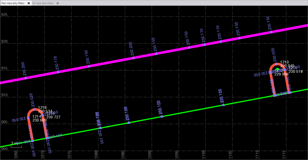
After the quality assurance phase, the next focus shifted towards the preparation of line work essential for curb layout. This involved elevating line work derived from the CAD file to establish precise elevations for curbs and other critical infrastructure elements.
Accurate line work is vital for ensuring proper drainage, accessibility, and aesthetics in urban planning. The engineering team utilized the rectified GPS data to create highly accurate line elevations that adhered strictly to the planned designs. This attention to detail is crucial for the successful implementation of infrastructure projects.
Creating Line Strings and Surfaces for GPS Data Prep
Following the elevation adjustments, the team proceeded to create line strings and surfaces that would be used in the GPS data preparation. Line strings are sequences of points that define specific paths or boundaries, while surfaces represent the terrain and contours of the project area.
These elements were meticulously crafted to ensure they corresponded accurately with the overall project specifications. The integration of line strings and surfaces into the GPS data preparation not only enhanced the operational efficiency of machinery on-site but also facilitated the future stages of construction planning.
3D Surface Creation for Machine Control
Developing a 3D Surface for Machine Control File
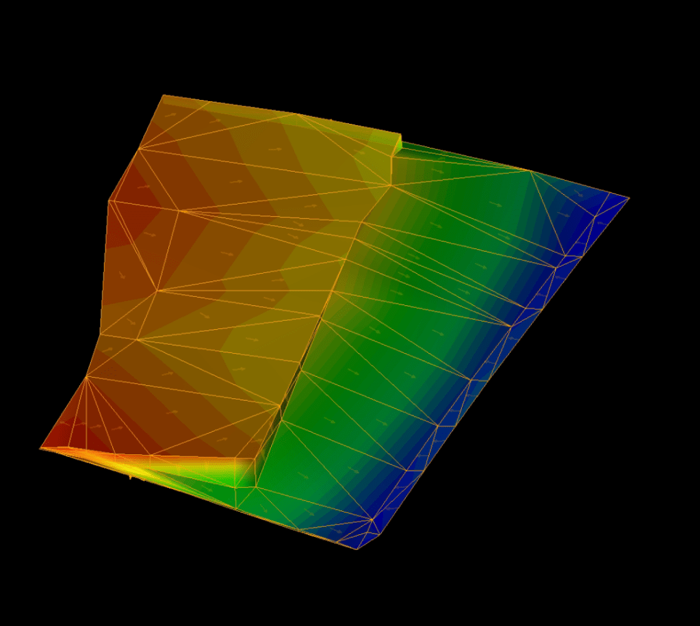
One of the final steps in the GPS data preparation process involved developing a 3D surface that would serve as a machine control file. This surface is critical for guiding heavy machinery during excavation, grading, and other construction activities.
The 3D surface was generated based on the compiled line work and surface data, ensuring that all aspects of the project were represented in three dimensions. This development not only optimized the machinery's performance but also significantly reduced the potential for human error during operation.
Benefits of 3D Surface in Engineering Projects
The implementation of a 3D surface in engineering projects offers several benefits, including enhanced visualization, improved coordination, and increased precision in construction. By allowing operators to visualize the project in three dimensions, the likelihood of miscommunication and mistakes diminishes substantially.
Moreover, the integration of 3D surface models into machine control systems provides real-time feedback, allowing for immediate adjustments based on actual site conditions. This adaptability is crucial in achieving project goals efficiently and effectively.
Conclusion
Summary of Achievements
This case study illustrates the meticulous process of GPS data preparation in precision engineering, highlighting the importance of accurate data acquisition, rigorous quality assurance, and the creation of necessary models for successful project execution. Each step, from initial file rectification to the development of machine control files, plays a vital role in ensuring that engineering projects are completed on time and within budget while meeting all technical specifications.

Future Implications for Engineering and Land Surveying
The integration of advanced technologies such as GPS data preparation will undoubtedly shape the future landscape of engineering and land surveying. As these methods become more refined and widely adopted, they will enhance project accuracy, reduce costs, and streamline processes across the industry. The continuous evolution of technology promises a future where precision engineering becomes even more efficient and effective, paving the way for innovative infrastructure solutions.
FAQs
What is GPS data preparation in engineering?
GPS data preparation in engineering refers to the process of collecting, rectifying, and utilizing GPS data to ensure that engineering designs are accurately executed on-site. It encompasses various steps, including data acquisition, localization, quality assurance, and the creation of control files for machinery.
How does GPS improve engineering accuracy?
GPS improves engineering accuracy by providing high-precision location data that can be integrated into design models. This real-time positional information allows engineers and operators to align construction activities with exact specifications, reducing risks of errors and misalignments.
What are the benefits of using 3D surfaces in construction?
Using 3D surfaces in construction offers numerous benefits, including enhanced visualization of the project, improved coordination among teams, and increased precision in guiding machinery. This approach minimizes human error and optimizes the overall construction process.
Why is quality assurance important in GPS data preparation?
Quality assurance is crucial in GPS data preparation as it ensures the accuracy and reliability of the data used throughout the engineering process. By verifying measurements and conducting checks, the likelihood of costly mistakes is significantly reduced.
What role do control points play in the rectification process?
Control points are reference markers used in the rectification process to align CAD models with real-world coordinates. These points enhance the accuracy of spatial data inputs and provide a framework for verifying the integrity of engineering designs.


Check out our many projects showcased on our Instagram page.


5 Key Benefits of GPS Data Processing for Elevated Project Success
Introduction
In the ever-evolving landscape of construction, accuracy and efficiency in surveying are paramount. Construction surveying serves as the backbone of any construction project, ensuring that all elements align correctly with design plans. This article explores how a new approach to construction surveying can dramatically improve efficiency, cost-effectiveness, and clarity in deliverables, making it an invaluable resource for business owners, engineers, and even consumers who play a role in the construction process.
Importance of Accurate Construction Surveying leading to Accurate GPS Data Processing
Accurate construction surveying establishes a solid foundation for successful projects. It impacts everything from initial planning to final execution. Whether it’s determining land boundaries or setting out building lines, precision is key. Mistakes in surveying can lead to costly reworks, project delays, and even legal disputes, emphasizing the need for reliable surveying services.
Furthermore, accurate data collection and analysis provide insights that can significantly enhance project management. By leveraging precise information, project managers can make informed decisions that mitigate risks and optimize resources. This not only ensures compliance with regulations but also builds trust with stakeholders involved.
Who We Are: Engineering and IT Backgrounds
Our team is comprised of professionals with extensive backgrounds in engineering and IT. This unique combination allows us to approach construction surveying from a holistic perspective, integrating the latest technology with traditional surveying methods. By understanding both the technical and practical aspects of surveying, we are well-equipped to provide innovative solutions that meet the demands of modern construction.
Our experience in these fields has honed our ability to utilize cutting-edge tools and methodologies, enabling us to deliver precise results efficiently. This blend of expertise ensures that we not only meet but exceed client expectations, making us a trusted partner in construction surveying.
Cost-Effective Solutions for Your Construction Needs
Saving You Money Without Compromising Quality
One of the most significant advantages of adopting our construction surveying services is cost savings. We employ techniques and technologies that reduce labor and material costs without sacrificing quality. By streamlining processes and utilizing advanced equipment, we can achieve results more quickly and accurately, which translates to substantial savings for your project.
Moreover, our focus on precision reduces the likelihood of errors, which can lead to costly rework. Investing in accurate surveying from the outset minimizes the potential for future expenses, making it a smart choice for budget-conscious business owners.
How Our Approach Reduces Overall Project Costs
Our methodology emphasizes efficiency at every stage of the construction process. For instance, employing robotic total stations and drones allows for faster data collection and processing, significantly reducing time on site. This not only shortens project timelines but also limits the costs associated with extended labor and equipment rental.
Additionally, by providing clear and accurate data, we help avoid design clashes and miscommunications that often lead to project delays and overruns. Our cost-effective GPS Data Processing solutions ensure that your investment yields maximum returns, steering projects towards successful completion.
Clarity and Simplicity in Deliverables
Providing Clean and Straightforward Files
In construction surveying, the clarity of deliverables is just as crucial as the accuracy of the data collected. We pride ourselves on providing clean, straightforward files that can be easily interpreted by architects, engineers, and construction teams. These deliverables are structured to enhance usability, making it simpler for stakeholders to access and utilize the data effectively.
Our commitment to clarity ensures that everyone involved in the project, from the design phase to construction and maintenance, has a clear understanding of the site conditions and requirements. This transparency reduces the chances of miscommunication and helps keep the project on track.
The Importance of User-Friendly Data in Construction
User-friendly data is essential for effective collaboration among various teams involved in construction. We understand that different stakeholders may have varying levels of technical expertise, so we tailor our deliverables to accommodate all users. By utilizing intuitive formats and annotations, we ensure that our data is accessible and easy to understand, facilitating better communication across the project landscape.
This focus on user-friendly data ultimately enhances decision-making processes and fosters a smoother workflow, leading to increased productivity and project success.
Quick Turnaround Time: Meeting Your Deadlines
Streamlined Processes for Faster Delivery
In the construction industry, time is often of the essence. Our streamlined processes enable us to deliver surveying results quickly without compromising quality. By leveraging technology and optimizing our workflow, we can significantly reduce the turnaround time from data collection to final deliverables.
Real-Life Examples of Quick Turnaround Success Stories
We have numerous success stories that demonstrate our commitment to quick turnaround times. For instance, one commercial project required urgent topographical surveys due to a sudden change in design plans. Our team mobilized quickly, utilizing drones for aerial data collection, which allowed us to deliver accurate results within a fraction of the usual time frame.
Another case involved a residential development where expedited surveying was crucial to meet local government deadlines. Our precise and rapid surveying techniques enabled the client to submit their plans on time, avoiding potential penalties and facilitating a smoother approval process.
Hands-On Experience: We Are Construction Surveyors
Real-World Insights from Field Experience
Our team comprises experienced construction surveyors who have worked on various projects across different sectors. This hands-on experience provides us with valuable insights that enhance our understanding of the challenges faced during construction.
We have navigated complex site conditions, design modifications, and regulatory hurdles, enabling us to offer practical solutions that address real-world problems. Our field experience informs our approach, making us adaptable and resourceful in even the most challenging situations.
The Value of a Boots-on-the-Ground Attitude
Having a boots-on-the-ground attitude means that we are not just passive observers; we actively engage with the project, ensuring that our surveys align with the evolving needs of the site. This proactive approach allows us to anticipate potential issues and adjust our strategies accordingly, ultimately leading to more successful outcomes.
Our commitment to being present on the site and understanding the nuances of each project sets us apart from traditional surveying firms. This dedication translates into greater accuracy and efficiency in our services.
High-Tech Solutions: Leveraging Over 10 Years of CAD Experience
Innovative Technologies in Construction Surveying
With over a decade of experience in CAD (Computer-Aided Design), we leverage technology to elevate our surveying services. Our expertise in CAD allows us to create detailed digital models that enhance the visualization of the project.
By integrating CAD with modern surveying equipment, we can produce high-quality deliverables that meet the demands of contemporary construction. These innovative technologies enable us to provide precise measurements and detailed plans that serve as a solid foundation for project execution.
How Our Expertise Enhances Project Efficiency
Our proficiency in CAD translates into improved efficiency at every stage of the construction process. By using advanced modeling techniques, we can identify potential design conflicts before construction begins, saving time and resources.
Additionally, CAD facilitates better collaboration among project teams, allowing for seamless integration of input from architects, engineers, and construction managers. This collaborative environment enhances overall project efficiency and drives successful outcomes.
GPS Data Processing and ensuring Compatibility with Any GPS or Machine Control System
Generic Files for Universal Use
Understanding the diverse technological landscape in construction, we ensure that our surveying outputs are compatible with any GPS or machine control system. Our generic file formats cater to various platforms, making it easy for clients to integrate our data into their existing systems.
This flexibility allows for seamless implementation, reducing the learning curve and minimizing disruptions in workflow. Our commitment to providing universally compatible files enhances our clients’ ability to utilize our data effectively.
Flexibility and Adaptability in Technology
In an industry marked by rapid technological advancements, our adaptability sets us apart. We constantly stay updated with the latest trends and innovations in surveying technology, enabling us to offer cutting-edge solutions tailored to our clients' needs.
This emphasis on flexibility ensures that we can pivot quickly to accommodate changes in technology or project requirements. By being adaptable, we can provide consistent support, regardless of the tools or systems our clients choose to use.
Conclusion
Choosing the right construction surveying partner is crucial for the success of your project. Our innovative approach, grounded in engineering and IT expertise, offers cost-effective solutions, clarity in deliverables, quick turnaround times, and compatibility with various technologies. We pride ourselves on our hands-on experience and commitment to leveraging high-tech solutions, ensuring that we meet the unique needs of each client.
Investing in our services means choosing a partner dedicated to enhancing your construction experience and project outcomes. We invite you to reach out and discover how our surveying solutions and GPS Data Processing can transform your approach to construction.
FAQs
1. What types of projects can benefit from your surveying services and GPS Data Processing? Our surveying services are suitable for a wide range of projects, including commercial buildings, residential developments, infrastructure projects, and land development.
2. How do you ensure the accuracy of your surveys? We utilize advanced surveying technologies and adhere to industry standards to ensure the accuracy of our data collection and analysis.
3. Can you adapt to specific project timelines? Yes, we prioritize meeting deadlines and can adapt our processes to accommodate urgent project timelines.
4. What are your deliverable formats? We provide deliverables in various formats, including CAD files, PDFs, and other user-friendly formats compatible with existing systems.
5. How do I get started with your services? Contact us to discuss your project requirements, and we will provide a tailored solution that fits your needs.



Elevate Your Construction Project with LiDAR Precision! 1 - Day Results on Complex Terrain
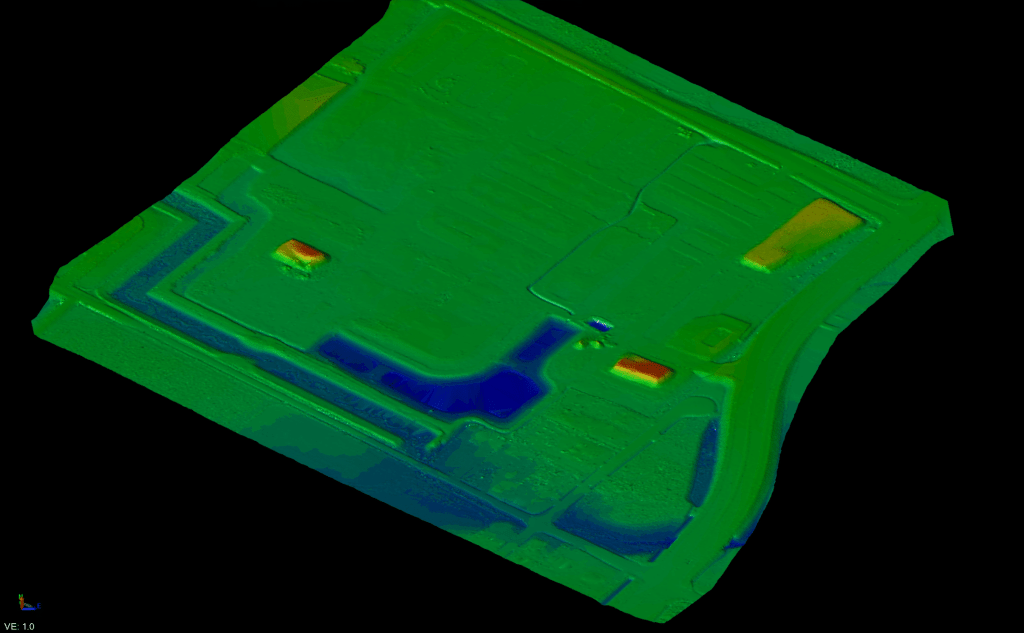
The project site presented significant challenges for construction due to an overabundance of excess fill and irregularly arranged piles; however, we solved this with a LiDAR scan.
Our client required a precise quantification of every cubic centimetre of material present on site before any work activities commenced.
To effectively address the complex and unique requirements of the new condominium development situated at the intersection of Jane Street and Highway 7 in Vaughan, Ontario, our dedicated team has implemented a careful, strategic approach to surveying. By integrating both LiDAR (Light Detection and Ranging) and GPS topographic surveying techniques, we ensured the creation of a comprehensive, detailed, and highly accurate map of all existing utilities and infrastructure well in advance of the commencement of our client’s construction activities.
At the outset, the project’s scope seemed straightforward: conduct a standard GPS as-built survey, with a primary focus on the area surrounding a planned parking lot. Early expectations were that GPS technology alone would provide sufficient data for the client’s needs. However, upon conducting a meticulous, hands-on inspection of the development site, we quickly uncovered a host of unforeseen complexities. Chief among these were extensive deposits of construction materials—namely, segregated gravel and topsoil—that had been deposited and accumulated over time in a somewhat disorganized and uneven manner. This haphazard distribution of materials drastically altered the site’s surface profile and presented a significant challenge for surface modeling, as it threatened the reliability and accuracy of any GPS-derived results.
Recognizing the limitations inherent in relying solely on GPS in environments marked by extensive and uneven material deposits, our team made a well-informed recommendation: to expand the survey scope by incorporating advanced LiDAR technology. LiDAR is an innovative remote sensing technique that utilizes laser pulses to measure variable distances to the earth, generating highly accurate and high-resolution three-dimensional representations of surface features and man-made structures. By deploying LiDAR across the site, we were able not only to capture the subtle variations in the landscape, but also to obtain vital data on the composition and distribution of materials, utilities, and existing infrastructural elements.
The integration of LiDAR into our workflow delivered significant benefits to both the surveying process and the ultimate project outcome. The data captured through LiDAR scanning enabled us to generate precise digital terrain models (DTMs) and digital surface models (DSMs), capturing the nuances of the current landscape with clarity unmatched by traditional methods. This comprehensive dataset empowered our client to make informed, data-driven decisions at every stage of their project, from planning and design through execution and post-construction verification.
Our team’s proficiency in leveraging cutting-edge tools and their capability to adapt the survey scope reflect our depth of knowledge in the application of advanced geomatics. By merging traditional GPS surveying with state-of-the-art LiDAR scanning, we were able to overcome site-specific challenges and supply our client with a superior quality deliverable, tailored to their exact specifications and construction timeline.
When you choose Stratus Aerial Geomatics for your LiDAR survey needs, you gain access to a host of distinct advantages. Our organization is dedicated to embracing the latest technological advancements, ensuring that every project benefits from the industry’s most effective tools and methodologies. Our commitment to ongoing professional development ensures that our personnel stay up-to-date with evolving practices and innovations, allowing us to maintain a standard of accuracy, efficiency, and safety that is second to none. The high-resolution data we capture is meticulously processed and tailored to address the unique objectives of each client and project, resulting in faster turnaround times and improved project outcomes.
Exceptional aerial surveying does not simply result from access to leading technology; rather, it is rooted in a deep understanding of our clients’ specific goals and concerns. Our friendly, approachable, and highly skilled team works closely with clients at every stage—from planning and data collection through to analysis and final reporting—ensuring that all relevant details are addressed and that no aspect of the project is overlooked.
Partnering with Stratus Aerial Geomatics means you are not merely contracting a surveying service, but are engaging a passionate, dedicated team genuinely invested in delivering excellence. We strive to foster strong client relationships, built on trust, open communication, and a shared drive for success. Together, we can transform challenging surveying requirements into opportunities for remarkable outcomes.
We invite you to experience firsthand the Stratus Aerial Geomatics difference. Let us help you realize the full potential of your development projects with precision, reliability, and innovation at every step.

Preparing for a LiDAR scan in Vaughan